
Some states are shaped by ideology. Others are shaped by crisis. Iran is shaped by geography. Long before modern political debates over sanctions, nuclear policy, or regional influence, the contours of the Iranian Plateau had already defined the space within which power would operate. Mountains shield its heartland, deserts slow intrusion, and the narrow waters of the Strait of Hormuz place it at the edge of global energy flows. Iran’s political posture — defensive yet assertive, resilient yet strategic — reflects a state acutely aware of the terrain beneath it. To understand Iran, one must first read its landscape.
Why this matters: Iran’s geography helps explain many of the tensions and strategic rivalries that shape Middle Eastern politics today.
A Plateau Protected by Mountains
Iran sits on the Iranian Plateau, a high-elevation region surrounded by mountain ranges. Two major mountain systems form natural barriers:
- Zagros Mountains in the west
- Alborz Mountains in the north
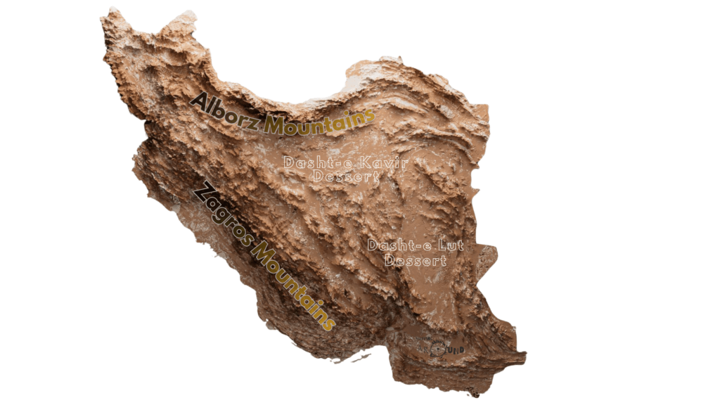
These mountains make access to Iran difficult. Historically, they acted as natural defensive walls that slowed invasions and protected the Iranian heartland.
Inside this mountain ring lie vast deserts such as:
- Dasht-e Kavir
- Dasht-e Lut
Together, these landscapes create a country that is naturally defensive and internally segmented.
Geography and the Iranian Sense of Security
The Iranian politics carries the memory of terrain.
Because of its terrain, Iran has often viewed security differently from many other states. The mountains make it difficult for foreign armies to move quickly across the country. The deserts create long logistical challenges for any invading force. As a result, Iran has historically relied on depth and geography for protection.
This helps explain why Iran’s strategic thinking often combines defensive caution with regional assertiveness.
The Strait of Hormuz: Geography as Leverage
One of the most important pieces of Iran’s geography lies to its south: the Strait of Hormuz. This narrow waterway connects the Persian Gulf to the open ocean.
If the Iranian Plateau provides depth, the Strait of Hormuz provides leverage.
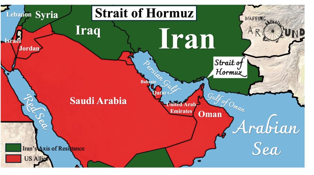
It is one of the world’s most important energy chokepoints. More than 20% of global oil exports pass through it. Because Iran sits along the northern side of the strait, geography gives it a powerful strategic position in global energy flows. Even when tensions rise in the region, the strait remains a reminder of how geography shapes geopolitics.
Iran as a Land Bridge
If the Strait of Hormuz connects Iran to maritime flows, its landmass connects entire regions.
Iran sits at the crossroads of Central Asia, South Asia, and the Middle East. This location has made it a natural land bridge between regions for centuries.
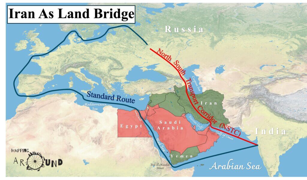
Trade routes connecting the Mediterranean world, Central Asia, and the Indian Ocean have historically passed through Iranian territory. Today, the same geography influences modern transport corridors, energy routes, and regional politics.
Iran is therefore not just a country — it is also a geographical connector between multiple regions.
Connectivity becomes strategy. Location becomes leverage.
How Iran Extends Its Influence Across the Middle East
The map below shows two main blocs in the region. On one side are Iran and its regional partners. On the other side are countries aligned with the United States and its allies.
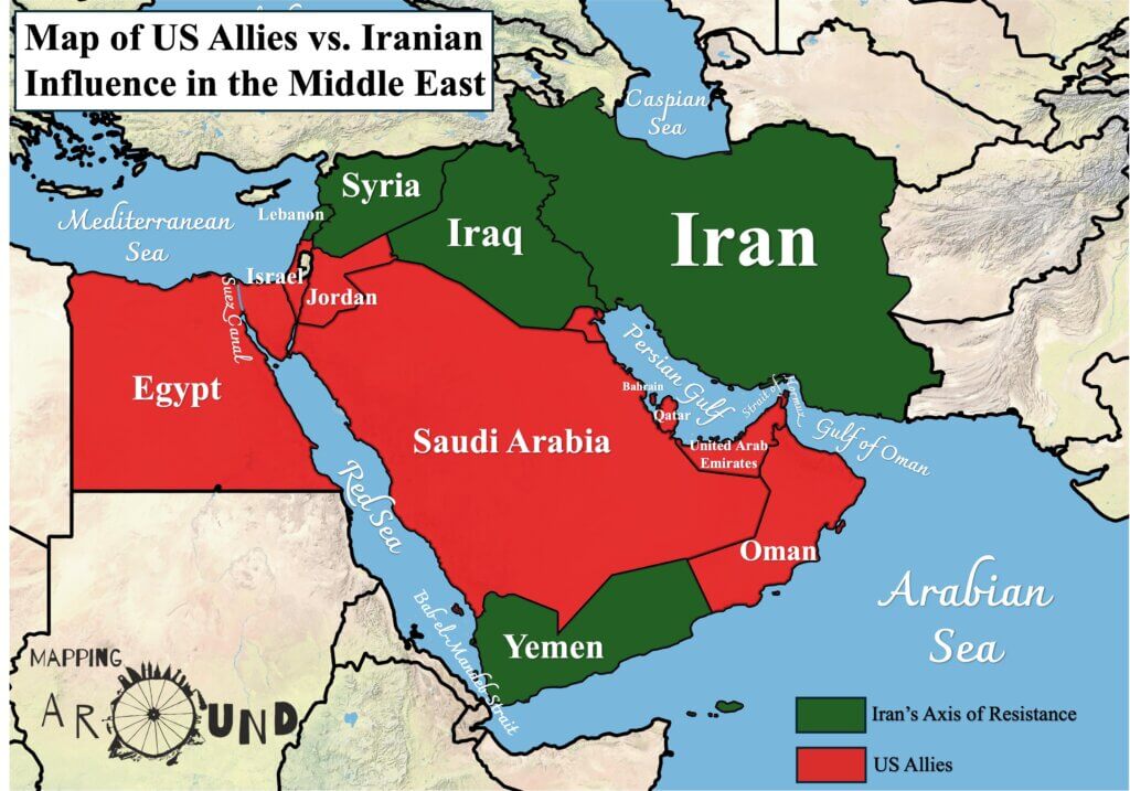
Iran’s influence often spreads through a network of allied governments and armed groups, sometimes called the “Axis of Resistance.” These groups operate in places such as Iraq, Lebanon, and Yemen, and share a common goal of countering U.S. and Israeli influence in the region.
By building relationships across several countries, Iran creates strategic depth beyond its borders. Instead of concentrating power solely within Iran, influence extends across parts of the Middle East.
This network forms a kind of geopolitical corridor linking Iran to the eastern Mediterranean and the Red Sea. As the map illustrates, regional politics often revolve around the interaction between Iran’s partners and U.S.-aligned states.
Understanding this map helps explain why many Middle Eastern conflicts are not isolated events. They are often part of a larger regional competition for influence.
Why Geography Matters in Iranian Politics
Modern politics often focuses on diplomacy, ideology, or military power. But in Iran’s case, geography continues to play a central role.
Mountains protect the interior.
Deserts’ slow movement.
Strategic waterways influence global energy routes.
Together, these features shape how Iran thinks about security, influence, and survival.
To understand Iran’s politics, one must first understand its landscape. Because in Iran, geography is not just background — it is strategy.