
What are air masses?
When the air has distinctive characteristics in terms of temperature and humidity, it is called an air mass. An air mass is a large body of air having little horizontal variation in temperature and moisture. They extend from the surface to the lower stratosphere and are spread across thousands of kilometres. These masses are usually spread out over several kilometres. When air stays over a surface long enough, it acquires the characteristics of that region. Therefore, an air mass is established when an extensive portion of the atmosphere has acquired some sort of equilibrium with the surface by remaining in contact over a long period. Hence, they are usually characterised by their origin, like Polar or Tropical air masses, as every air mass is related to a planetary wind system. Air masses can also be classified as maritime or continental, depending on whether they form over land or water. As they move and interact with other air masses, they can cause weather patterns and storms. The concept of air masses helps us understand weather patterns, especially in the temperate regions.
Every air mass is related to the permanent wind belt. Tropical maritime and tropical continental air masses are found in the trade wind belts.
Contribution of Vilhelm Bjerknes
Vilhelm Bjerknes (1862-1951) was a Norwegian meteorologist who made significant contributions to the understanding of weather systems and the development of modern meteorology. Bjerknes developed the idea of air masses and their interactions, known as fronts, which is still a fundamental concept in meteorology today. The terminology of ‘front’ was inspired by World War, as this concept evolved during that time. In 1921, he published his classic work “On the Dynamics of the Circular Vortex with Applications to the Atmosphere and to Atmospheric Vortex and Wave Motion.”
His work laid the foundation for the development of numerical weather prediction, which uses computer models to forecast the weather.
Air Masses and Source Regions
The homogenous surfaces, over which air masses form, are called the source regions. The main source regions are the high-pressure belts in the subtropics (giving rise to tropical air masses) and around the poles (the source for polar air masses). The source region establishes heat and moisture equilibrium with the overlying air mass. When an air mass moves away from a source region, the upper level maintains the physical characteristics for a longer period. This is possible because air masses are stable with stagnant air, which does not facilitate convection. Conduction and radiation in such stagnant air are not effective.
The source region should be extensive with gentle, divergent air circulation (slightly at high pressure). Areas with high pressure but little pressure difference or pressure gradient are ideal source regions. There are no major source regions in the mid-latitudes, as these regions are dominated by cyclonic and other disturbances

Conditions for the formation of air masses
- Stable atmospheric conditions – The air mass must remain over the region of origin long enough for it to pick up the temperature and moisture characteristics of the underlying surface.
- Large homogeneous regions – The region of origin must be large enough and have a uniform temperature and moisture profile to allow for the development of a distinct air mass.
- Slowing of air mass movement – The movement of the air mass must slow down or stop, allowing it to pick up the temperature and moisture characteristics of the underlying surface.
- Lack of vertical mixing – The air mass must be prevented from mixing vertically with surrounding air, so that it retains its temperature and moisture characteristics.
These conditions are typically met over large, flat regions of the Earth’s surface, such as oceans and continents, and the formation of air masses is influenced by factors such as the time of year, latitude, and prevailing weather patterns.
Classification of Air Masses
Air masses are formed under the influence of the underlying surface, they are categorised based on five major source regions.

1. Warm tropical and subtropical oceans;
2. The subtropical hot deserts;
3. The relatively cold high-latitude oceans;
4. The very cold snow-covered continents in high latitudes;
5. Permanently ice-covered continents in the Arctic and Antarctica.

• Accordingly, the following types of air masses are recognised:
1. Maritime tropical (mT);
2. Continental tropical (cT);
3. Maritime polar (mP);
4. Continental polar (cP);
5. Continental arctic (cA).

P = Polar
c = continental
K = Heated from below
s = stable aloft
T = Tropical
m = maritime
W = Cooled from below
u = unstable
Broadly, the air masses are classified into polar and tropical air masses. Both the polar and the continental air masses can be either maritime or continental types.
Continental Polar Air Masses (cP)
- Source regions of these air masses are the Arctic basin, northern North America, Eurasia and Antarctica.
- These air masses are characterised by dry, cold and stable conditions.
- The weather during winter is frigid, clear and stable.
- During summer, the weather is less stable with a lesser prevalence of anticyclonic winds, warmer landmasses and less snow.
Maritime Polar Air Masses (mP)
- The source region of these air masses is the oceans between 40° and 60° latitudes.
- These are actually those continental polar air masses which have moved over the warmer oceans, got heated up and have collected moisture.
- The conditions over the source regions are cool, moist and unstable. These are the regions which cannot lie stagnant for long.
- The weather during winters is characterised by high humidity, overcast skies and occasional fog and precipitation.
- During summer, the weather is clear, fair and stable.
Continental Tropical Air Masses (cT)
- The source regions of the air masses include tropical and sub-tropical deserts of the Sahara in Africa, West Asia and Australia.
- These air masses are dry, hot and stable and do not extend beyond the source.
- They are dry throughout the year.
Maritime Tropical Air Masses (mT)
- The source regions of these air masses include the oceans in the tropics and sub-tropics, such as the Mexican Gulf, the Pacific and the Atlantic oceans.
- These air masses are warm, humid and unstable.
- The weather during winter has mild temperatures and overcast skies with fog.
- During summer, the weather is characterised by high temperatures, high humidity, cumulus clouds and convectional rainfall.
Air Fronts
Understanding Front Formation and Types of Fronts is important to understand the formation of Mid-latitude cyclones [temperate cyclones or extra-tropical cyclones] and the dominant weather patterns of mid-latitudes. Fronts are the typical features of midlatitude weather (temperate region 30° – 65° N and S). They are uncommon (unusual) in tropical and polar regions. The front is a three-dimensional boundary zone formed between two converging air masses with different physical properties(temperature, humidity, density, etc.). The two air masses don’t merge readily due to the effect of the converging atmospheric circulation, relatively low diffusion coefficient and low thermal conductivity.
How are fronts formed?
The process of formation of a front is known as Frontogenesis (war between two air masses), and the dissipation of a front is known as Frontolysis (one of the air masses wins against the other). Frontogenesis involves the convergence of two distinct air masses. Frontolysis involves the overriding of one of the air masses by another. In the northern hemisphere, Frontogenesis (convergence of air masses) happens in the anti-clockwise direction and in the southern hemisphere in the clockwise direction. This is due to the Coriolis effect. Mid-latitude cyclones / temperate cyclones / extra-tropical cyclones occur due to frontogenesis.
Frontogenesis Vs Frontolysis
Frontogenesis strengthens and concentrates temperature gradients between air masses, forming sharp weather fronts with active weather like precipitation and winds. Frontolysis, on the other hand, weakens and disperses these gradients, blurring fronts and leading to calmer weather as the front dissipates. Imagine the paint gradually blending as you separate the tubes. Both processes are crucial in shaping our dynamic weather patterns.
| Process | Temperature Gradient | Wind Convergence | Weather Effects | Importance |
| Frontogenesis | Strengthening | Convergence | Precipitation, strong winds | Formation of weather fronts |
| Frontolysis | Weakening | Divergence | Calmer weather | Dissipation of weather fronts |
Characteristics of fronts
- The temperature contrast influences the thickness of the frontal zone in an inverse manner, i.e., two air masses with higher temperature differences do not merge readily. So the front formed is less thick.
- With a sudden change in temperature through a front, there is a change in pressure also.
- The front experiences a wind shift since the wind motion is a function of pressure gradient and Coriolis force.
(Wind Shift: A change in wind direction of 45 degrees or more in less than 15 minutes with sustained wind speeds of 10 knots or more throughout the wind shift.
1 knot = 1.852 kmph
1 Nautical Mile = 1.852 km)
- The frontal activity is invariably associated with cloudiness and precipitation because of the ascent of warm air, which cools down adiabatically, condenses and causes rainfall.
- The intensity of precipitation depends on the slope of ascent and the amount of water vapour present in ascending air.
Classification of fronts

Weather map symbols:
1. cold front
2. warm front
3. stationary front
4. occluded front
5. surface trough
6. squall/shear line
7. dry line
8. tropical wave
9. trowal
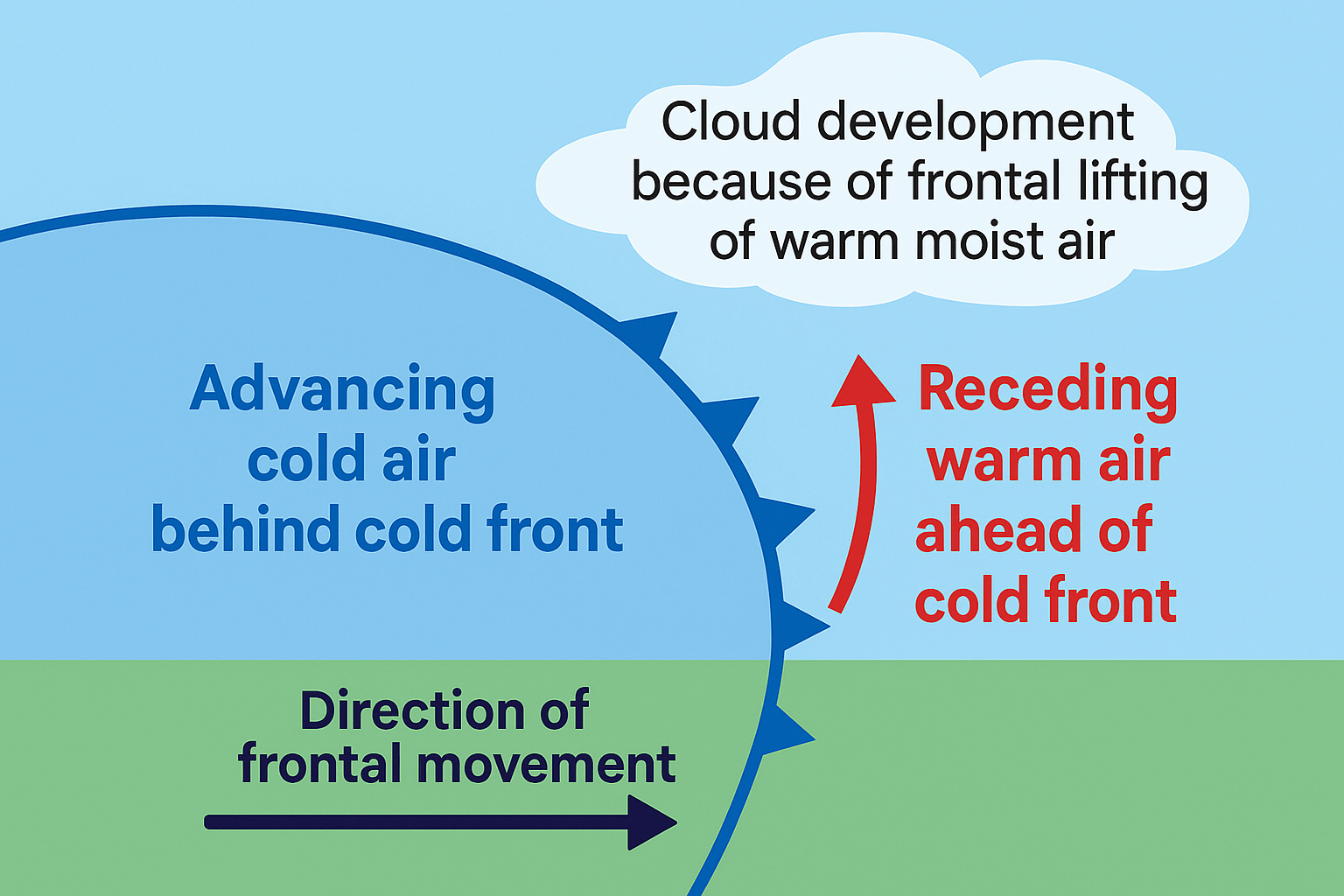
Cold Front

Such a front is formed when a cold air mass replaces a warm air mass by advancing into it or when the warm air mass retreats and the cold air mass advances (cold air mass is the clear winner).
- In such a situation, the transition zone between the two is a cold front.
- Cold front moves up to twice as quickly as warm fronts.
- Frontolysis begins when the warm air mass is completely uplifted by the cold air mass.
Weather along a cold front
The weather along such a front depends on a narrow band of cloudiness and precipitation.
Severe storms can occur. During the summer months, thunderstorms are common in the warm sector.
In some regions, like the USA, tornadoes occur in the warm sectors.
Produce sharper changes in weather. Temperatures can drop more than 15 degrees within the first hour.
Cloud formation along a cold front
The approach of a cold front is marked by increased wind activity in the warm sector and the appearance of cirrus clouds, followed by lower, denser altocumulus and altostratus.
At the actual front, dark nimbus and cumulonimbus clouds cause heavy showers. A cold front passes off rapidly, but the weather along it is violent.
Cloud formation along a cold front
The approach of a cold front is marked by increased wind activity in the warm sector and the appearance of cirrus clouds, followed by lower, denser alto-cumulus and altostratus.
At the actual front, dark nimbus and cumulonimbus clouds cause heavy showers. A cold front passes off rapidly, but the weather along it is violent.
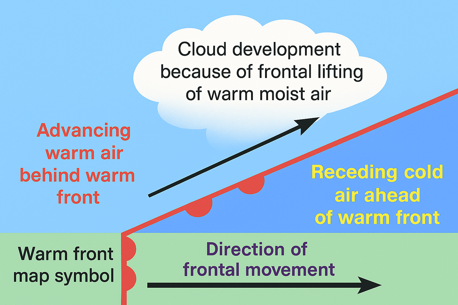
Warm Front

It is a sloping frontal surface along which active movement of warm air over cold air takes place (warm air mass is too weak to beat the cold air mass).
Frontolysis (front dissipation) begins when the warm air mass makes way for the cold air mass on the ground, i.e. when the warm air mass completely sits over the cold air mass.
Weather along a warm front
As the warm air moves up the slope, it condenses and causes precipitation, but, unlike a cold front, the temperature and wind direction changes are gradual.
Such fronts cause moderate to gentle precipitation over a large area, over several hours.
The passage of a warm front is marked by a rise in temperature, pressure and a change in weather.
Clouds along a warm front
With the approach, the hierarchy of clouds is—cirrus, stratus and nimbus. [No cumulonimbus clouds as the gradient is gentle]
Cirrostratus clouds ahead of the warm front create a halo around the sun and moon.
Stationary Front

When the surface position of a front does not change (when two air masses are unable to push against each other; a draw), a stationary front is formed.
The wind motion on both sides of the front is parallel to the front.
The warm or cold front stops moving, hence the name stationary front.
Once this boundary resumes its forward motion, it becomes a warm front or cold front.
Weather along a stationary front
Cumulonimbus clouds are formed. Overrunning of warm air along such a front causes frontal precipitation.
Cyclones migrating along a stationary front can dump heavy amounts of precipitation, resulting in significant flooding along the front.
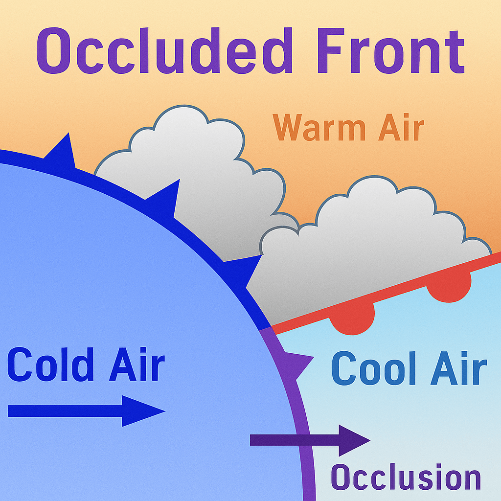
Occluded Front

Occlusion in Meteorology is a process by which the cold front of a rotating low-pressure system catches up with the warm front so that the warm air between them is forced upwards.
Such a front is formed when a cold air mass overtakes a warm air mass and goes underneath it.
Frontolysis begins when the warm sector diminishes and the cold air mass completely undertakes the warm sector on the ground.
Thus, a long and backward swinging occluded front is formed, which could be a warm front type or cold front type occlusion.
Weather along an occluded front
Weather along an occluded front is complex—a mixture of cold front-type and warm front-type weather. Such fronts are common in Western Europe.
The formation of Mid-latitude cyclones [temperate cyclones or extra-tropical cyclones] involves the formation of an occluded front.
Clouds along an occluded front
A combination of clouds formed at the cold front and warm front.
Warm front clouds and cold front clouds are on opposite sides of the occlusion