
Indian Monsoons
- The term monsoon has been derived from the Arabic word mausim, meaning ‘season’.
- Monsoons are seasonal winds (Rhythmic wind movements)(Periodic Winds) which reverse their direction with the change of season.
- The monsoon is a double system of seasonal winds – They flow from sea to land during the summer and from land to sea during winter.
- Some scholars tend to treat the monsoon winds as land and sea breeze on a large scale.
- Monsoons are peculiar to Indian Subcontinent, South East Asia, parts of Central Western Africa etc..
- They are more pronounced in the Indian Subcontinent compared to any other region.
- Indian Monsoons are Convection cells on a very large scale.
- They are periodic or secondary winds which seasonal reversal in wind direction.
- India receives south-west monsoon winds in summer and north-east monsoon winds in winter.
- South-west monsoons are formed due to intense low pressure system formed over the Tibetan plateau.
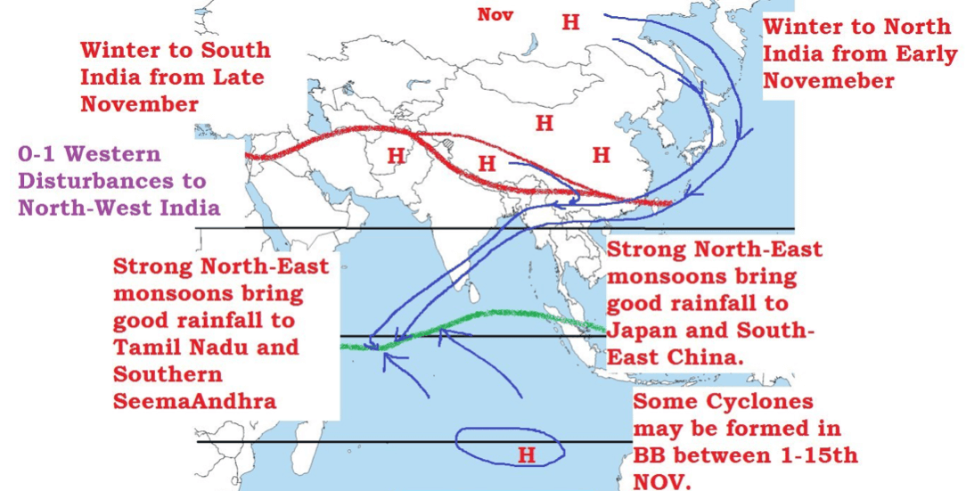
- North-east monsoons are associated with high pressure cells over Tibetan and Siberian plateaus.
- South-west monsoons bring intense rainfall to most of the regions in India and north-east monsoons bring rainfall to mainly south-eastern coast of India (Southern coast of Seemandhra and the coast of Tamil Nadu.).
- Countries like India, Indonesia, Bangladesh, Myanmar etc. receive most of the annual rainfall during south-west monsoon season where as South East China, Japan etc., during north-east rainfall season.
Factors responsible for south-west monsoon formation
- Intense heating of Tibetan plateau during summer months.
- Permanent high pressure cell in the South Indian Ocean (east to north-east of Madagascar in summer).
Factors that influence the onset of south-west monsoons
- Above points +
- Subtropical Jet Stream (STJ).
- Tropical Easterly Jet (African Easterly Jet).
- Inter Tropical Convergence Zone.
Factors that influence the intensity of south-west monsoons
- Strengths of Low pressure over Tibet and high pressure over southern Indian Ocean.
- Somali Jet (Findlater Jet).
- Somali Current (Findlater Current).
- Indian Ocean branch of Walker Cell.
- Indian Ocean Dipole.
Factors responsible for north-east monsoon formation
- Formation and strengthening of high pressure cells over Tibetan plateau and Siberian Plateau in winter.
- Westward migration and subsequent weakening of high pressure cell in the Southern Indian Ocean.
- Migration of ITCZ to the south of India.
All these will be discussed in detail.
Mechanism of Indian Monsoons
- The origin of monsoons is not fully understood.
- There are several theories that tried to explain the mechanism of monsoons.
Classical Theory
- Monsoons are mentioned in scriptures like the Rig Veda. But these scriptures didn’t make any mention of the monsoon mechanism.
- The first scientific study of the monsoon winds was done by Arab traders.
- Arab traders used the sea route to carry out trade with India and monsoon patterns were of prime importance for them.
- In the tenth century, Al Masudi, an Arab explorer, gave an account of the reversal of ocean currents and the monsoon winds over the north Indian Ocean.
- In seventeenth century, Sir Edmund Halley explained the monsoon as resulting from thermal contrasts between continents and oceans due to their differential heating.
Modern Theories
- Besides differential heating, the development of monsoon is influenced by the shape of the continents, orography (mountains), and the conditions of air circulation in the upper troposphere {jet streams}.
- Therefore, Halley’s theory has lost much of its significance and modern theories based on air masses and jet stream are becoming more relevant.
Indian Monsoons – Classical Theory: Sir Edmund Halley’s Theory
Summer Monsoon
- In summer the sun’s apparent path is vertically over the Tropic of Cancer resulting in high temperature and low pressure in Central Asia.
- The pressure is sufficiently high over Arabian Sea and Bay of Bengal. Hence winds flowed from Oceans flow towards landmass in summer.
- This air flow from sea to land bring heavy rainfall to the Indian subcontinent.
Winter Monsoon
- In winter the sun’s apparent path is vertically over the Tropic of Capricorn.
- The north western part of India grows colder than Arabian Sea and Bay of Bengal and the flow of the monsoon is reversed.
- The basic idea behind Classical theory is similar to land and sea breeze formation except that in the case of monsoons the day and night are replaced by summer and winter.
Drawbacks: The monsoons do not develop equally everywhere on earth and the thermal concept of Halley fails to explain the intricacies of the monsoons such as the sudden burst of monsoons, delay in on set of monsoons sometimes, etc..
Indian Monsoons – Modern theory: Air Mass Theory
- According to this theory, the monsoon is simply a modification of the planetary winds of the tropics.
- The theory is based on the migration of ITCZ based on seasons.
Indian Monsoons – Role of ITCZ [Inter-Tropical Convergence Zone]
- The southeast trade winds in the southern hemisphere and the northeast trade winds in the northern hemisphere meet each other near the equator.
The meeting place of these winds is known as the Inter-Tropical Convergence Zone (ITCZ).
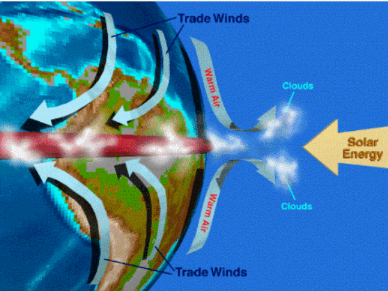
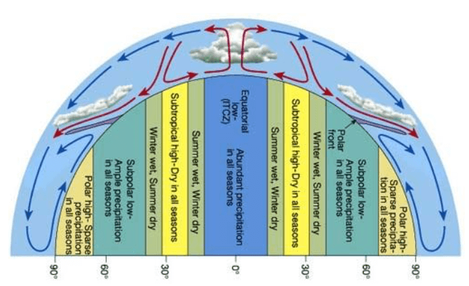
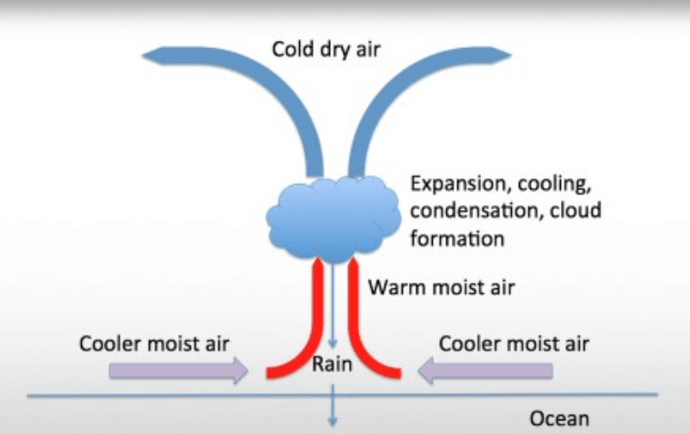
- This is the region of ascending air, maximum clouds and heavy rainfall.
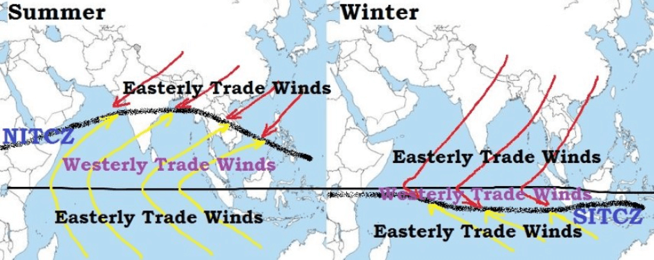
- The location of ITCZ shifts north and south of equator with the change of season.
- In the summer season, the sun shines vertically over the Tropic of Cancer and the ITCZ shifts northwards.
- The southeast trade winds of the southern hemisphere cross the equator and start blowing in southwest to northeast direction under the influence of Coriolis force.
- These displaced trade winds are called south-west monsoons when they blow over the Indian sub-continent.
- The front where the south-west monsoons meet the north-east trade winds is known as the Monsoon Front (ITCZ). Rainfall occurs along this front.
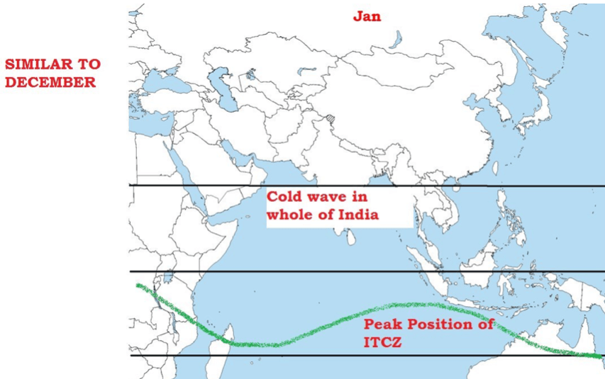
- In the month of July the ITCZ shifts to 20°- 25° N latitude and is located in the Indo-Gangetic Plain and the south-west monsoons blow from the Arabian Sea and the Bay of Bengal. The ITCZ in this position is often called the Monsoon Trough [maximum rainfall].
- The seasonal shift of the ITCZ has given the concept of Northern Inter-Tropical Convergence Zone (NITCZ) in summer (July – rainy season) and Southern Inter-Tropical Convergence Zone (SITCZ) in winter (Jan – dry season).
- NITCZ is the zone of clouds and heavy rainfall that effect India.
Indian Monsoon Mechanism – Jet Stream Theory. Role of Sub-Tropical Jet Stream (STJ). Why no south-west monsoons during winter? Why no south-west monsoons in March – May (summer)?
Indian Monsoon Mechanism – Jet Stream Theory
Indian Monsoon Mechanism – Modern Theory: Jet Stream Theory.
- Jet stream Theory is the latest theory regarding the origin of the monsoons and has earned worldwide acceptance from the meteorologists.
- To understand how Jet streams affect Indian monsoons, we need to know the basic mechanism of Jet Stream induced weather conditions.
How Jet Streams Affect Weather?
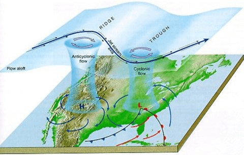
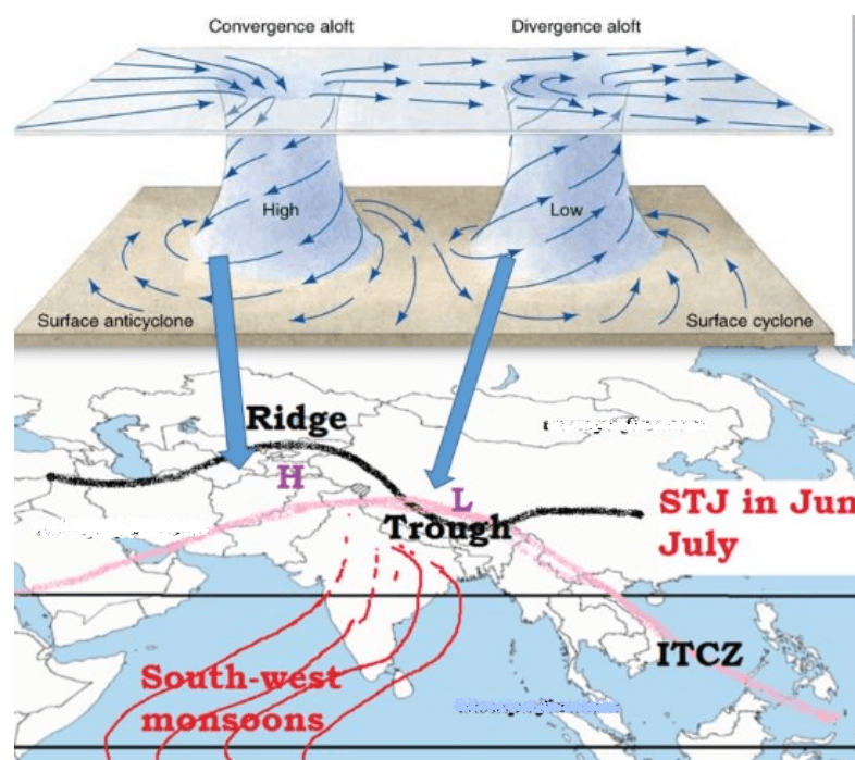
- Jet streams have distinct peaks (ridges) and troughs.
- Ridges occur where the warm air mass pushes against the cold air mass. Troughs occur where cold air mass drops into warm air.
- The region on earth below the trough is at low pressure and the region below ridge is at high pressure.
- This condition occurs due to weakening of jet stream due to lesser temperature contrast between sub-tropics and temperate region (Our concern is STJ only).
- Usually the trough region [the region exactly below the jet stream trough] creates cyclonic condition (low pressure) at the surface of earth whereas the ridge regions creates anticyclonic condition.
- Troughs create upper level divergence which is associated with convergence at the surface (low pressure – cyclonic conditions) and ridges create upper level convergence which is associated with divergence at the surface (high pressure – cyclonic conditions).
- These ridges and troughs give rise to jet streaks which are also responsible for cyclonic and anticyclonic weather conditions at the surface.
- The winds leaving the jet streak are rapidly diverging, creating a lower pressure at the upper level (Tropopause) in the atmosphere. The air below rapidly replaces the upper outflowing winds. This in turn creates the low pressure at the surface. This surface low pressure creates conditions where the surrounding surface winds rush inwards. The Coriolis effect creates the cyclonic rotation (cyclonic vortex) that is associated with depressions [low pressure cells].
- The winds entering the jet streak are rapidly converging because of the high pressure at the upper level (Tropopause) in the atmosphere. This convergence at upper troposphere leads to divergence (high pressure) at the surface (anticyclonic condition).
- The Coriolis effect creates the anticyclonic rotation that is associated with clear weather.
But how does this mechanism of jet streams influence Indian Monsoons?
Indian Monsoon Mechanism – Role of Sub-Tropical Jet Stream (STJ)
- Sub-Tropical Jet stream plays a significant role in both hindering the monsoon winds as well as in quick onset of monsoons.
STJ – Sub-Tropical Jet Stream
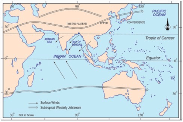
- Sub-Tropical Jet stream is a narrow band of fast moving air flowing from west to east [Westerlies].
- STJ in northern hemisphere flows between 25° to 35° N in the upper troposphere at a height of about 12-14 km (all this already discussed in previous posts on Jet Streams). (Here we will consider STJ only. Polar Jet has no influence on Indian monsoons).
- The wind speeds in a westerly jet stream are commonly 150 to 300 km p.h. with extreme values reaching 400 km p.h.
The burst of monsoons depends upon the upper air circulation which is dominated by STJ.
Seasonal Migration of Sub-Tropical Jet Stream – STJ
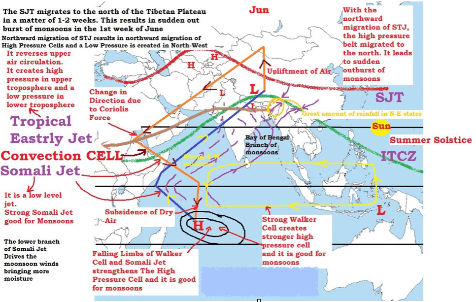
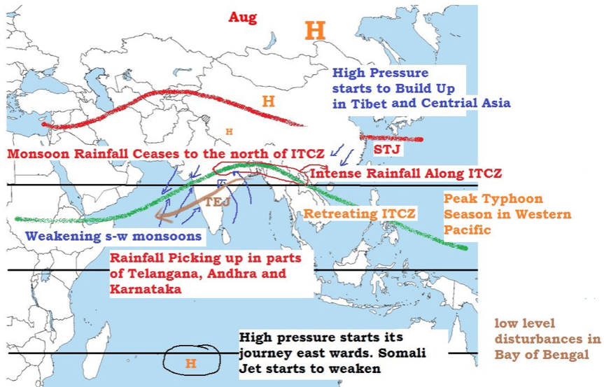
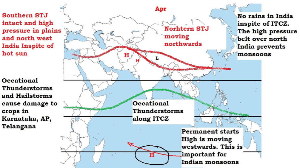
- In winter STJ flows along the southern slopes of the Himalayas but in summer it shifts northwards, rather dramatically, and flows along the northern edge of Himalayas in early June and in late summer (July-August) along the northern edge of the Tibetan Plateau.
- The periodic movement of the Jet stream is often the indicator of the onset (STJ shits to the north of Himalayas in a matter of days) and subsequent withdrawal (STJ returns back to its position – south of Himalayas) of the monsoon.
- Northward movement of the subtropical jet is the first indication of the onset of the monsoon over India.
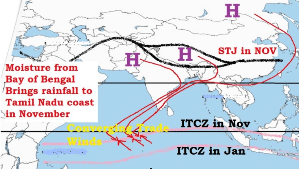
Sub-Tropical Jet Stream – STJ in Winter
- Westerly jet stream blows at a very high speed during winter over the sub-tropical zone.
- This jet stream is bifurcated by the Himalayan ranges and Tibetan Plateau.
- The two branches reunite off the east coast of China.
- The northern branch of this jet stream blows along the northern edge of the Tibetan Plateau.
- The southern branch blows to the south of the Himalayan ranges along 25° north latitude.
- A strong latitudinal thermal gradient (differences in temperature), along with other factors, is responsible for the development of southerly jet.
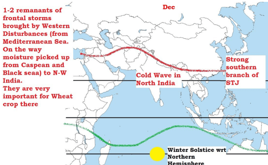
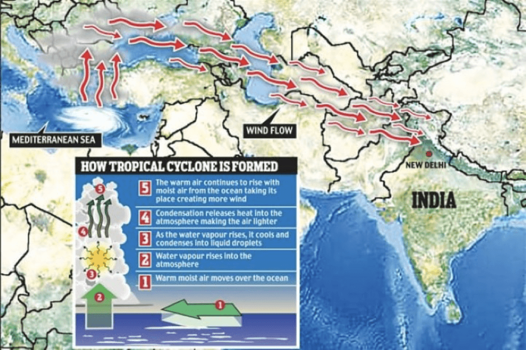
Western Disturbances
- Meteorologists believe that southern branch of jet stream exercises a significant influence on the winter weather conditions in India.
- The upper jet is responsible for steering of the western depressions [Western Disturbances] from the Mediterranean Sea.
- Some of the depressions continue eastwards, redeveloping in the zone of jet stream confluence about 30° N, 105° E (near east coast of China).
- Winter rain and heat storms in north-western plains and occasional heavy snowfall in hilly regions are caused by these disturbances.
- These are generally followed by cold waves in the whole of northern plains.
- The southern branch is stronger, with an average speed of about 240 km compared with 70 to 90 km p.h. of the northern branch.
- Air subsiding beneath this upper westerly current gives dry out blowing northerly winds from the subtropical anticyclone over northwestern India and Pakistan.
Why no south-west monsoons during winter?
- Reason 1: ITCZ has left India (the winds that blow over India are mostly offshore –– land to land or land to ocean –– so they carry no moisture).
- Reason 2: During winter, the southern branch of STJ is strong and is to the south of Himalayas. The ridge of the jet lies over north-western India and is associated with strong divergence of winds and creates a high pressure region (sub-tropical high pressure belt) over entire north India. [This is how the mechanism of jet streams influence Indian Monsoons in winter season]
- Reason 3: There is already a strong high pressure over Tibet. [High Pressure due to STJ + High Pressure over Tibet = strong divergence = no rainfall]
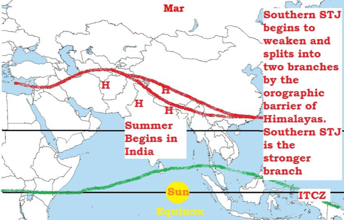
Sub-Tropical Jet Stream – STJ in Summer
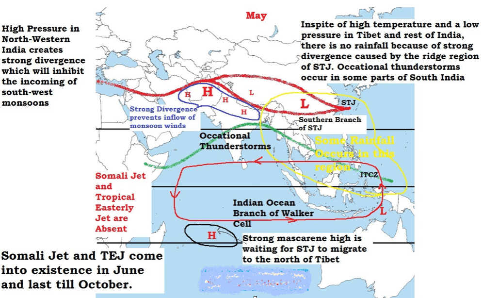
- With the beginning of summer in the month of March, the STJ [upper westerlies] start their northward march.
- The southerly branch of STJ remains positioned south of Tibet, although weakening in intensity.
- The weather over northern India becomes hot, dry and squally due to larger incoming solar radiation and hot winds like loo.
- Over India, the Equatorial Trough (ITCZ) pushes northwards with the weakening of the STJ [upper westerlies] south of Tibet, but the burst of the monsoon does not take place until the upper-air circulation has switched to its summer pattern.
- By the end of May the southern jet breaks and later it is diverted to the north of Tibet Plateau and there is sudden burst of monsoons (the ridge moves northwards into Central Asia = high pressure over north-west India moves northwards into Central Asia = makes way for south-west monsoon winds). An Easterly jet emerges over peninsular India with the northward migration of STJ.
- The upper air circulations are reversed with the emergence of Easterly jet [convergence in upper layers is replaced by divergence == divergence in lower layers is replaced with convergence == high pressure at lower layers is replaced by low pressure system]. The easterly winds become very active in the upper troposphere and they are associated with westerly winds in the lower troposphere (south-west monsoon winds).
- Western and eastern jets flow to the north and south of the Himalayas respectively. The eastern jet becomes powerful and is stationed at 15° N latitude.
- This results in more active south-west monsoon and heavy rainfall is caused.
Why no south-west monsoons in March – May (summer)?
- There is good sun’s insolation from March – May but still there is no s-w monsoons.
Reason: The ridge region of Southern branch of STJ creates strong divergence (high pressure) in north-west India. The diverging air blocks incoming winds and prevents strong convergence of winds along ITCZ.
- During the summer season in the Northern Hemisphere, low pressure areas develop at the ground surface near Peshawar (Pakistan) and north-west India due to intense heating of ground surface during April, May, and June.
- As long as the position of the upper air jet stream is maintained above the surface low pressure (to the south of Himalayas), the dynamic anti-cyclonic conditions persist over north-west India.
- The winds descending from the upper air high pressure [because of the trough of STJ] obstructs the ascent of winds from the surface low pressure areas, with the result that the weather remains warm and dry.
- This is why the months of April and May are generally dry and rainless in spite of high temperatures (low pressure on land) and high evaporation.
Indian Monsoons – Role of Tropical Easterly Jet (TEJ) [African Easterly Jet]
- The establishment and maintenance of the TEJ is not fully understood but it is believed that the jet may be caused by the uniquely high temperatures and heights over the Tibetan Plateau during summer.
- The TEJ plays an important role in kick starting southwest monsoon.
- This jet descends over the Indian Ocean (near Madagascar) and intensifies its high pressure cell so as to move as south-west monsoon.
Tropical Easterly Jet (TEJ)
- There are major high velocity winds in the lower troposphere called low-level jets (LLJs).
- In the tropics, the most prominent of these are the Somali Jet and the African Easterly Jet [Tropical Easterly Jet].
- The TEJ is a unique and dominant feature of the northern hemispheric summer over southern Asia and northern Africa. The TEJ is found near between 5° and 20°N.
- It is fairly persistent in its direction, and intensity from June through the beginning of October. It’s position fluctuates between 5° and 20°N.
- TEJ comes into existence quickly after the STJ has shifted to the north of the Himalayas (Early June).
- TEJ flows from east to west over peninsular India at 6 – 9 km and over the Northern African region.
- The formation of TEJ results in the reversal of upper air circulation patterns [High pressure switches to low pressure] and leads to the quick onset of monsoons.
- Recent observations have revealed that the intensity and duration of heating of Tibetan Plateau has a direct bearing on the amount of rainfall in India by the monsoons.
- When the summer temperature of air over Tibet remains high for a sufficiently long time, it helps in strengthening the easterly jet and results in heavy rainfall in India.
- The easterly jet does not come into existence if the snow over the Tibet Plateau does not melt. This hampers the occurrence of rainfall in India.
- Therefore, any year of thick and widespread snow over Tibet will be followed by a year of weak monsoon and less rainfall.
Indian Monsoons – Role of Tibet
- The Tibetan Plateau is an enormous block of highland acting as a formidable barrier.
- Due to its protruded height it receives 2-3°C more insolation than the neighboring areas.
- The plateau affects the atmosphere in two ways: (a) as a mechanical barrier, and (b) as a high- level heat sources.
- At the beginning of June the subtropical jet stream is completely withdrawn from India and occupies a position along 40° N (to the north of Tibetan Plateau).
- The plateau accentuates the northward displacement of the jet stream. Hence the burst of monsoon in June is prompted by the Himalayas and not by the thermally induced low pressure cell over Tibet. (Tibetan plateau is responsible for south-west monsoons. But it is the STJ that facilitates sudden outburst of monsoons with its sudden northward migration)
- In the middle of October the plateau proves to be the most important factor in causing the advance of the jet south of the Himalayas or bifurcating it into two parts.
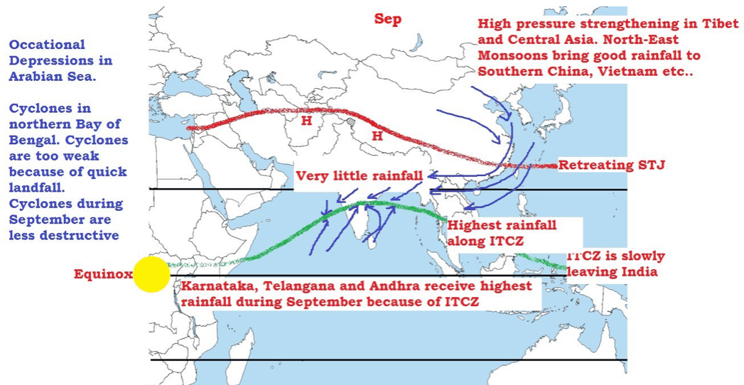
- The winter Tibetan Plateau cools rapidly and produces a high pressure cell. (Cyclonic condition over Tibet ceases and an anticyclonic condition is established). The high pressure cell over Tibet strengthens N-E monsoons.
- Tibet gets heated in summer and is 2°C to 3°C warmer than the air over the adjoining regions.
- Because the Tibet Plateau is a source of heat for the atmosphere, it generates an area of rising air (convergence)(intense low pressure cell).
- During its ascent the air spreads outwards in upper troposphere (divergence) and gradually sinks (subsidence) over the equatorial part of the Indian Ocean.
- It finally approaches the west coast of India as a return current from a south-westerly direction and is termed as equatorial westerlies.
- It picks up moisture from the Indian Ocean and causes rainfall in India and adjoining countries.
Indian Monsoons – Role of Somali Jet
- Polar and subtropical jet streams are the permanent jet streams which greatly influence the weather of temperate regions.
- Temporary jet streams are narrow winds with speeds more than 94 kph in the upper, middle and sometimes in lower troposphere. They are few. Important ones are Somali Jet and The African Easterly jet or Tropical Easterly Jet.
- These two jet streams play an important role in the formation and progression of Indian Monsoons.
- The progress of the southwest monsoon towards India is greatly aided by the onset of Somali jet that transits Kenya, Somalia and Sahel.
- It was observed to flow from Mauritius and the northern part of the island of Madagascar before reaching the coast of Kenya at about 3º S.
- It strengthens permanent high near Madagascar and also helps to drive S-W monsoons towards India at a greater pace and intensity.
- The importance of the low level jet arises from the fact that its path around 9º N coincides with a zone of coastal upwelling.
- As the strong winds drive away the surface coastal waters towards the east, extremely cold water from the depths of the sea rise upwards to preserve the continuity of mass.
- The peculiar feature of Somali Current is reversal in direction with the onset of the summer monsoon.
- In winter, this current is from north to the south running southwards from the coast of Arabia to the east African coastline; but with the advent of the summer monsoon it reverses its direction and flows from the south to the north.
Indian Monsoons – Role of Indian Ocean Dipole
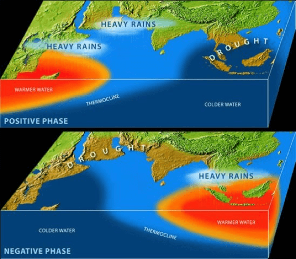
- Indian ocean Dipole is a recently discovered phenomena that has a significant influence on Indian monsoons.
- Indian ocean Dipole is a SST anomaly (Sea Surface Temperature Anomaly – different from normal) that occurs occasionally in Northern or Equatorial Indian Ocean Region (IOR).
- The Indian Ocean Dipole (IOD) is defined by the difference in sea surface temperature between two areas (or poles, hence a dipole) – a western pole in the Arabian Sea (western Indian Ocean) and an eastern pole in the eastern Indian Ocean south of Indonesia.
- IOD develops in the equatorial region of Indian Ocean from April to May peaking in October.
- With a positive IOD winds over the Indian Ocean blow from east to west (from Bay of Bengal towards Arabian Sea). This results in the Arabian Sea (western Indian Ocean near African Coast) being much warmer and eastern Indian Ocean around Indonesia becoming colder and dry.
- In the negative dipole year, reverse happens making Indonesia much warmer and rainier.
- Positive IOD is good for Indian Monsoons as more evaporation occurs in warm water.
- Similar to ENSO, the atmospheric component of the IOD is named as Equatorial Indian Ocean Oscillation (EQUINOO)(Oscillation of pressure cells between Bay of Bengal and Arabian Sea).
- During the positive phase of the ‘Equatorial Indian Ocean Oscillation (EQUINOO),’ there is enhanced cloud formation and rainfall in western part of the equatorial ocean near the African coast while such activity is suppressed near Sumatra.
- While EQUINOO and IOD go in step during strong positive IOD events, they do not always do so.
How Jet Streams affect the Monsoons in the Indian Sub-Continent?
Summing up all the points above.
- As the summer time approaches, there is increased solar heating of the Indian subcontinent and the Tibetan Plateau.
- In the peak summer months (25th of May – 10th of Jun), with the apparent northward movement of the sun, the southern branch of the SJT, which flows to the south of the Himalayas, shifts to the north of the Himalayas.
- When the sun’s position is about to reach the Tropic of Cancer (June), the SJT shifts to the north of the Tibetan Plateau (1st of Jun – 20th of June). The ITCZ is close to its peak position over the Tibetan Plateau.
- The altitude of the mountains initially disrupts the jet but once it has cleared the summits it is able to reform over central Asia.
- Its movement towards the north is one of the main features associated with the onset of the monsoon over India.
- With the northward shift of SJT, an Easterly Jet is formed over the Indian plains. It generally forms in the first week of June and lasts till late October.
- It can be traced in the upper troposphere right up to the west coast of Africa.
- The northward shift of SJT and ICTZ moves the subtropical high pressure belt to the north of the Tibetan Plateau and the Easterly Jet creates a low pressure region in the Indian plains (Easterly Jet creates anticyclonic conditions in upper troposphere).
- This low pressure in the northern plains coupled with the intense low of the Tibetan Plateau leads to the sudden onset of south-west monsoons (1st of Jun – 20th of June).
- The monsoon cell is situated between the Indian Ocean (North of Madagascar)(High Pressure Cell) and Tibetan plateau (Low Pressure Cell).
- In summer the sub-tropical easterly jet fluctuates between the plains region of India and peninsular India varying the intensity of rainfall from location to location.
- During March to May, the building up of this cell is blocked by the STJ which tends to blow to the south of the Himalayas (Northwest India and Plains region are occupied by Subtropical High Pressure Belt. This high pressure belt undermines the influence of low pressure cell over Tibet).
- As long as the STJ is in this position the development of summer monsoons is inhibited (the high pressure belt stays over north India).
- With the STJ out of the way (high pressure belt migrates to the north of Tibet) the sub continental monsoon cell develops (Somali Jet) very quickly indeed, often in a matter of a few days.
- Warmth and moisture are fed into the cell by a lower level tropical jet stream which brings with it air masses laden with moisture from the Indian Ocean.
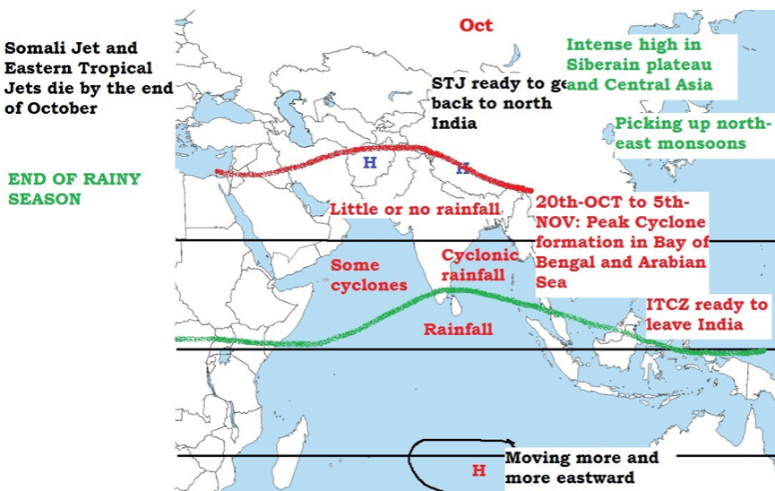
- The end of the monsoon season is brought about when the atmosphere over the Tibetan Plateau begins to cool (August – October), this enables the STJ to transition back across the Himalayas.
- With the southward shift of ITCZ, subtropical high pressure belt returns back to the Indian plains and the rainfall ceases.
- This leads to the formation of a anticyclonic winter monsoon cell typified by sinking air masses over India and relatively moisture free winds that blow seaward.
- This gives rise to relatively settled and dry weather over India during the winter months.

Projects to understand monsoons
- First attempt was made during International India Ocean Expedition (HOE) from 1962 to 1965.
- It was organized jointly by the International Council of Scientific Unions (ICSU), Scientific Committee on Ocean Research (SCOR) and UNESCO with World Meteorological Organization (WMO) joining the meteorology programme.
ISMEX
- Two more experiments were conducted, jointly, by India and the former USSR in 1973 and 1977, with limited participation from other countries.
- These experiments are known as the Indo-Soviet Monsoon Experiment (ISMEX) and Monsoon-77 respectively.
MONEX
- Data collection effort was made under the aegis of MONEX-1979.
- It was organised jointly by many researching organizations and the World Meteorological Organisation (WMO) under their World Weather Watch (WWW) programme.
- It is so far the largest scientific effort made to understand monsoons.
- Details are not necessary. Remember the names. They can be asked in prelims. MONEX was asked in previous papers.
Western Disturbances
- In the winter season, the sub-tropical jet (STJ) is bifurcated into two branches due to physical obstruction of the Himalayas and Tibetan Plateau.
- One branch is flows to the south of the Himalayas, while the second branch is positioned to the north of the Tibetan Plateau.
- The ridge of the jet stream creates anticyclonic (with clockwise air circulation) conditions over North-West India.
- Consequently, the winds tend to descend over the north-western parts of India, resulting into the development of atmospheric stability and dry conditions (anticyclonic condition = no rainfall).
- But the sub-tropical jet (STJ) causes periodic changes in general weather conditions.
- The STJ drives the temperate low pressures over Mediterranean Sea towards east across Afghanistan, Pakistan and reach north-west India.
- These storms are residual frontal cyclones which move at the height of 2000 metres from the mean sea level.
- On an average, 4 to 6 cyclonic waves reach north-western India between October and April each year.
Weather associated with Western Disturbances
- The arrival of these temperate storms [remnants of temperate cyclones] [western disturbances] causes precipitation leading to an abrupt decrease in air temperature over North-West India.
- The weather becomes clear after the western disturbances passes away.
- Western Disturbances also bring heavy snowfall in the Himalayan Region and a cold wave to north Indian plains.
Importance of Western DisturbancesThe western disturbances affect weather conditions during the winter season up to Patna (Bihar) and give occasional rainfall which is highly beneficial for the standing rabi crops, (wheat, barley, mustard, gram, lentil, etc.).