
The scale is where the art and science combine as a map without a scale is just a sketch.
A Scale can be defined as the ratio between a distance on the drawn map to the actual distance on the ground.
If a simple ratio of 1:1000 is taken this would mean 1 unit on map will represent 1000 unit on the ground. This simple relationship between distances on the ground and on map is known as a scale.
This relationship can be expressed in three ways
(a) Statement of Scale (Verbal Scale)
(b) Representative Fraction (RF)
(c) Graphical Scale
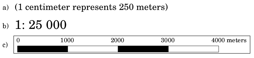
Each of these methods has its benefits and drawbacks over others but usually, you will find more than one represented in combination on a map.
While interpreting these relationships we require a system of measurement. Its to be noted that RF (Representative Fraction) are just units and can be interpreted in any system of measurement.
Two system of measurements are
(a) English System of Measurement (i.e. Mile, Furlong, Yard, Foot, Inch)
(b) Metric System of Measurement ( i.e. Kilometre, Hectometre, Decametre, etc.)
English System of Measurement
1 Mile = 8 Furlongs
1 Furlong = 220 Yards
1 Yard = 3 Feet
1 Foot = 12 Inches
Metric System of Measurement
1 Kilometer = 10 Hectometers
1 Hectometer = 10 Decameters
1 Decameter = 10 Meters
1 Meter = 10 Decimeters
1 Decimeter = 10 Centimeters
1 Centimeter = 10 Millimeters