
- What are tropical cyclones?
- Conditions favourable for formation of a tropical cyclone
- Coriolis Force – the cyclone maker
- ITCZ & low level disturbances
- Upper air disturbances
- Humidity Factor
- Origin and Development of Tropical Cyclones
- Structure of a tropical cyclone
- Favourite Breeding Grounds for Tropical Cyclones
- Regional names for Tropical Cyclones
- Characteristics of a Tropical Cyclones
What are tropical cyclones?
Tropical cyclones are violent storms that originate over oceans in tropical areas and move over to the coastal areas bringing about large scale destruction due to violent winds (squalls), very heavy rainfall (torrential rainfall) and storm surge.
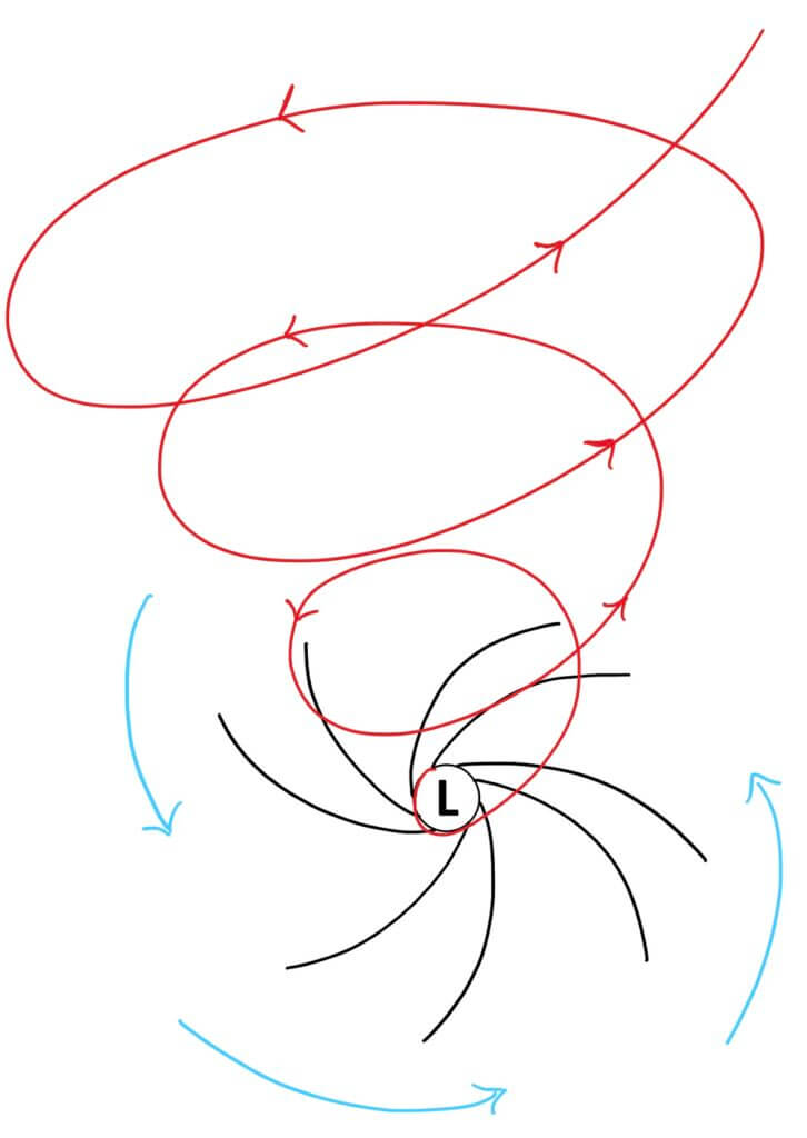
They are irregular wind movements with closed circulation of air around a low pressure centre [Figure 1(L)]. This closed air circulation (whirling motion) is a result of rapid upward movement of hot air [Fig. 1 (Red lines)] which is subjected to Coriolis force. The low pressure at the centre is responsible for the wind speeds.
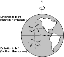
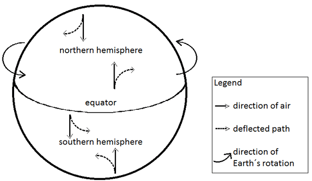
The cyclonic wind movements are anti-clockwise in the northern hemisphere and clockwise in the southern hemisphere (This is due to Coriolis force) [Fig.2]. The cyclones are often characterised by the existence of an anticyclone between two cyclones.
Direction of Tropical Cyclones in both hemispheres
Image Source
Figure 3 :An anti-clockwise cyclone in northern hemisphere.
Conditions favourable for formation of a tropical cyclone
- Large sea surface with temperature higher than 27° C
- Presence of the Coriolis force enough to create a cyclonic vortex
- Small variations in the vertical wind speed
- A pre-existing weak low-pressure area or low-level-cyclonic circulation
- Upper level air divergence, above the sea level system
- A good source of latent heat (moisture)
Ocean waters having temperatures of 27° C or more is the source of moisture which feeds the storm. The condensation of moisture releases enough latent heat of condensation to drive the storm.

Why
Tropical cyclones form mostly on the western margins of the oceans?
Tropical cyclones don’t form in the eastern tropical oceans?
This is because the depth of warm water (26-27°C) should extend for 60-70 m from surface of the ocean/sea, so that deep convection currents within the water do not churn and mix the cooler water below with the warmer water near the surface (Fig. 4)
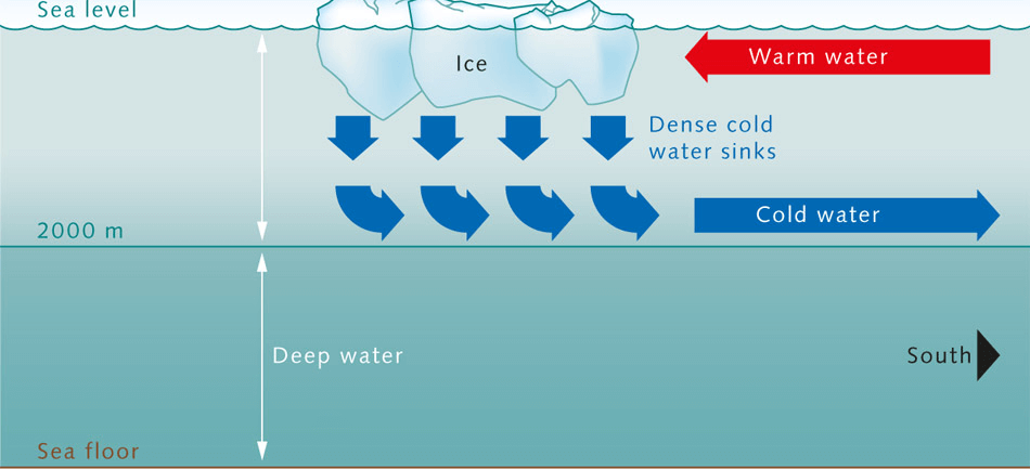
Image Source
(Image Source)
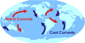
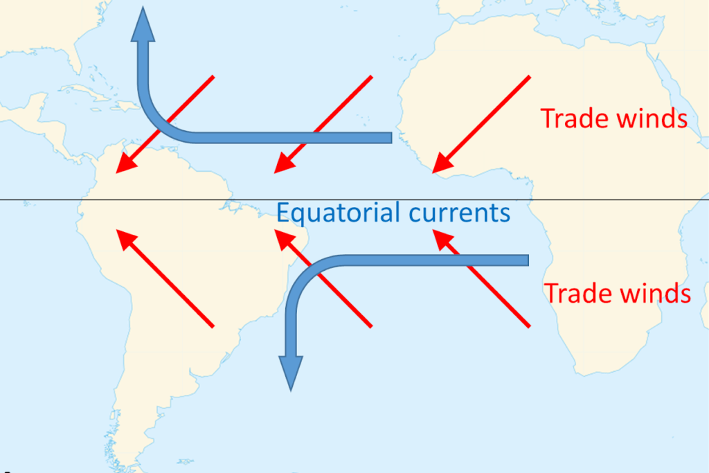
This above condition occurs only in western tropical oceans (Fig. 5) because of warm ocean currents (easterly trade winds pushes ocean waters towards west (Fig.7) that flow from east towards west forming a thick layer of water with temperatures greater than 27°C. This supplies enough moisture to the storm.
The cold currents lower the surface temperatures of the eastern parts of the tropical oceans making them unfit for the breeding of cyclonic storms.
[One Exception: During strong El Nino years, strong hurricanes occur in the eastern Pacific. This is due to the accumulation of warm waters in the eastern Pacific due to weak Walker Cell]
Coriolis Force – the cyclone maker
At Equator coriolis force is Zero => Hence no deflection => No cyclone
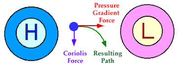
From 5° latitude onwards coriolis is considerable enough to deflect winds and form a Cyclonic Vortex. 65% of cyclones are found between 10° to 20° latitude. As air in a Small local area heats and rises it creates a low pressure region. Differences in the temperature of water and air produce various low pressure centers of small size.When a pressure gradient force is created air from high pressure rushes towards the low pressure region (Fig.8) but its deflected towards the right in the northern hemisphere and towards the left in the southern hemisphere (Fig.9). When the coriolis is strong enough a circular vortex is formed (Fig. 10).
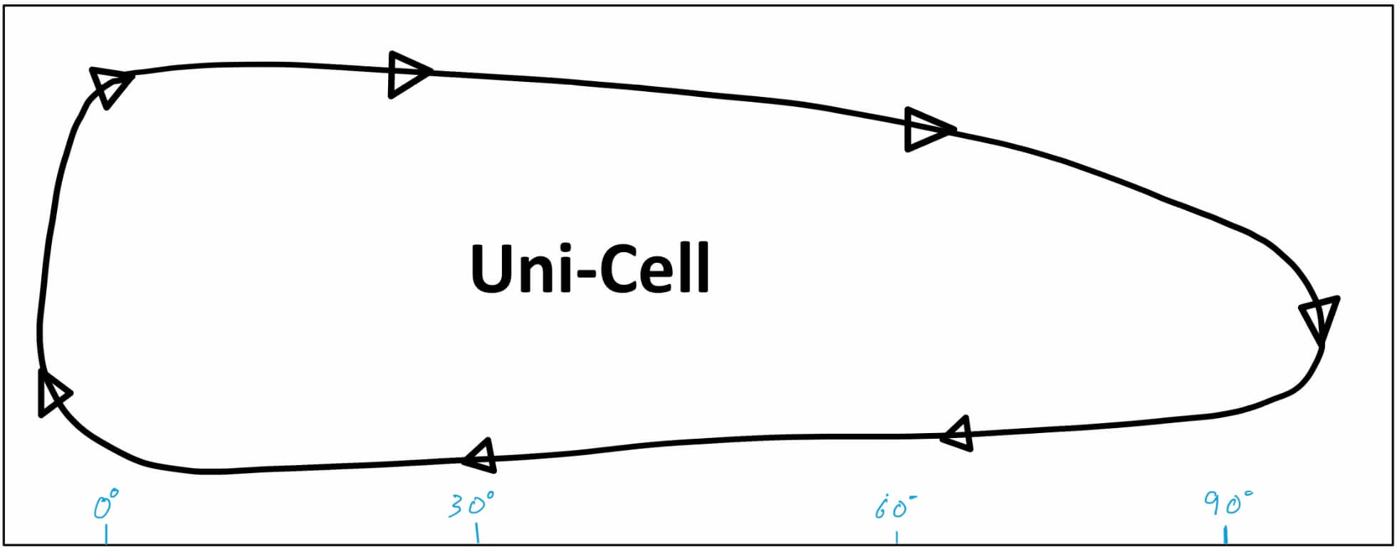
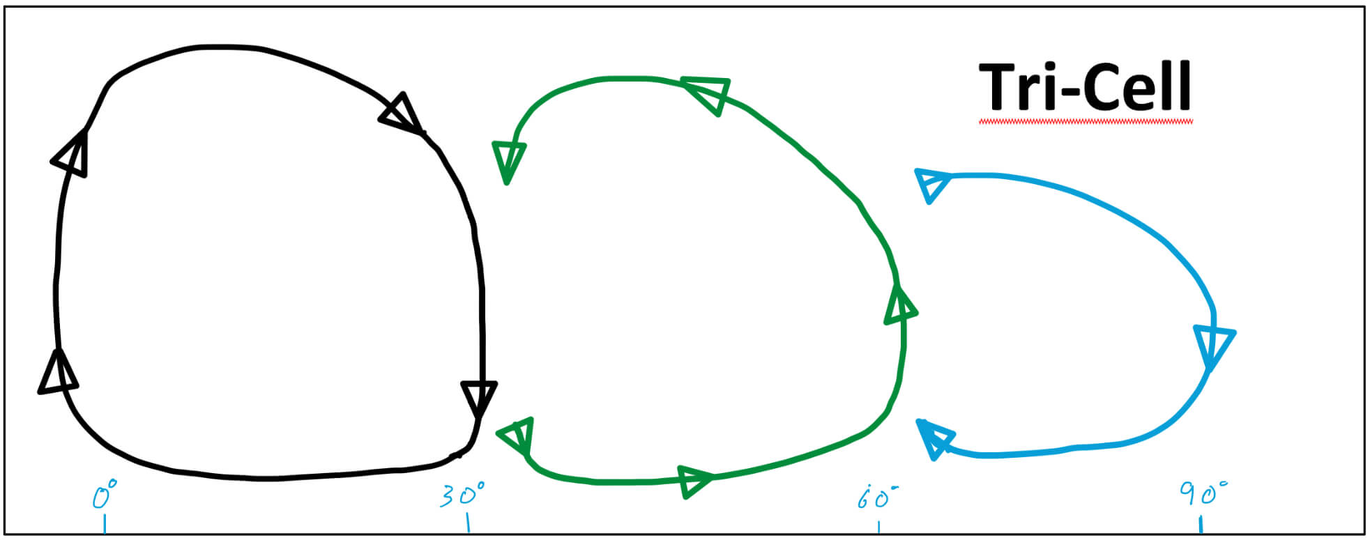
Coriolis force is one of the main reasons why the atmospheric circulation pattern is broken into three cells (Fig. 12) instead of one (Fig. 11).
ITCZ & low level disturbances
Low-level disturbances or thunderstorms are the seeds of cyclones and are induced by ITCZ.
ITCZ provides two major components to a cyclone – The warming of ocean water & a trigger for convection of hot air upward.
Temperature contrast between air masses
• Trade winds from both the hemispheres meet along the inter-tropical front. Temperature contrasts between these air masses must exist when the ITCZ is farthest, from the equator.

• Thus, the convergence of these air masses of different temperatures and the resulting instability are the prerequisites for the origin and growth of violent tropical storms.
When the light warm air (easterly wind) rushes to the region of low pressure it deflects and whirls and rises up (Fig. 1).
Because of the rising warm humid air, a true cyclonic vortex may develop very rapidly. However, only a few of these disturbances develop into cyclones.
[Rising of humid air => adiabatic lapse rate => fall in temperature of air => condensation of moisture in air => latent heat of condensation released => air gets more hot and lighter => air is further uplifted => more air comes in to fill the gap => new moisture available for condensation => latent heat of condensation and the cycle repeats]
Upper air disturbances
The remains of an upper tropospheric cyclone from the Westerlies move deep into the tropical latitude regions. As divergence prevails on the eastern side of the troughs, a rising motion occurs; this leads to the development of thunderstorms.
Further, these old abandoned troughs (remnants of temperate cyclones) usually have cold cores, suggesting that the environmental lapse rate is steeper and unstable below these troughs. Such instability encourages thunderstorms (child cyclones).
Upper Tropospheric Divergence
A well – developed divergence in the upper layers of the atmosphere is necessary so that the rising air currents within the cyclone continue to be pumped out and a low pressure maintained at the center.
Humidity Factor
High humidity (around 50 to 60 per cent) is required in the mid-troposphere, since the presence of moist air leads to the formation of cumulonimbus cloud.Such conditions exist over the equatorial doldrums, especially in western margins of oceans (this is because of east to west movement of ocean currents), which have great moisture, carrying capacity because the trade winds continuously replace the saturated air.
Origin and Development of Tropical Cyclones
The tropical cyclones have a thermal origin, and they develop over tropical seas during late summers (August to mid-November).
• At these locations, the strong local convectional currents acquire a whirling motion because of the Coriolis force.
• After developing, these cyclones advance till they find a weak spot in the trade wind belt.
Origin
Under favorable conditions, multiple thunderstorms originate over the oceans. These thunderstorms merge and create an intense low pressure system (wind is warm and lighter).
Early stage
• In the thunderstorm, air is uplifted as it is warm and light. At certain height, due to lapse rate and adiabatic lapse rate, the temperature of air falls and moisture in the air undergoes condensation.
• Condensation releases latent heat of condensation making the air more warmer. It becomes much lighter and is further uplifted.
The space is filled by fresh moisture laden air. Condensation occurs in this air and the cycle is repeated as long as the moisture is supplied.
• Due to excess moisture over oceans, the thunderstorm intensifies and sucks in air at much faster rate. The air from surroundings rushes in and undergoes deflection due to Coriolis force creating a cyclonic vortex (spiraling air column. Similar to tornado).
• Due to centripetal acceleration (centripetal force pulling towards the center is countered by an
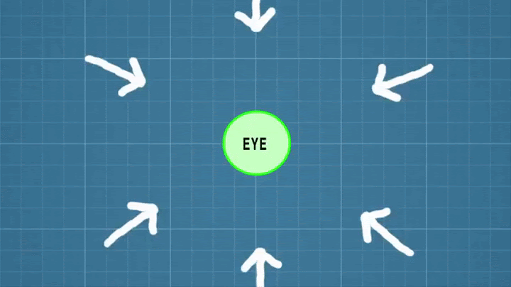
opposing force called centrifugal force), the air in the vortex is forced to form a region of calmness called an eye at the center of the cyclone. The inner surface of the vortex forms the eye wall, the most violent region of the cyclone.
[Eye is created due to tangential force acting on wind that is following a curvy path]
• All the wind that is carried upwards loses its moisture and becomes cold and dense. It descends to the surface through the cylindrical eye region and at the edges of the cyclone.
• Continuous supply of moisture from the sea is the major driving force behind every cyclone. On reaching the land the moisture supply is cut off and the storm dissipates.
• If ocean can supply more moisture, the storm will reach a mature stage.
Mature stage
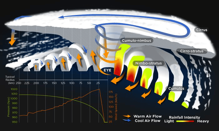
• At this stage, the spiraling winds create multiple convective cells with successive calm and violent regions.
• The regions with cumulonimbus cloud (rising limbs of convective cell) formation are called rain bands below which intense rainfall occurs.
• The ascending air will lose moisture at some point and descends (subsides) back to surface through the calm regions (descending limbs of convection cell – subsiding air) that exist between two rain bands.
• Cloud formation is dense at the center. The cloud size decreases from center to periphery.
• Rain bands are mostly made up of cumulonimbus clouds. The ones at the periphery are made up of nimbostratus and cumulus clouds.
• The dense overcast at the upper levels of troposphere is due to cirrus clouds which are mostly made up of hexagonal ice crystals.
• The dry air flowing along the central dense overcast descends at the periphery and the eye region.
Structure of a tropical cyclone
Eye
• The “eye” is a roughly circular area of comparatively light winds and fair weather found at the center of a severe tropical cyclone.
• There is little or no precipitation and sometimes blue sky or stars can be seen.
• The eye is the region of lowest surface pressure and warmest temperatures aloft (in the upper levels) – the eye temperature may be 10°C warmer or more at an altitude of 12 km than the surrounding environment, but only 0-2°C warmer at the surface in the tropical cyclone.
• Eyes range in size from 8 km to over 200 km across, but most are approximately 30-60 km in diameter.
Eye wall
• The eye is surrounded by the “eye wall”, the roughly circular ring of deep convection, which is the area of highest surface winds in the tropical cyclone. Eye Wall region also sees the maximum sustained winds i.e. fastest winds in a cyclone occur along the eye wall region.
• The eye is composed of air that is slowly sinking and the eye wall has a net upward flow as a result of many moderate – occasionally strong – updrafts and downdrafts [Explained in ‘Thunderstorms’].
• The eye’s warm temperatures are due to compressional warming (adiabatic) of the subsiding air.
• Most soundings taken within the eye show a low-level layer, which is relatively moist, with an inversion above – suggesting that the sinking in the eye typically does not reach the ocean surface, but instead only gets to around 1-3 km of the surface.
Spiral bands
• Another feature of tropical cyclones that probably plays a role in forming and maintaining the eye is the eye wall convection.
• Convection in tropical cyclones is organized into long, narrow rain bands which are oriented in the same direction as the horizontal wind.
• Because these bands seem to spiral into the center of a tropical cyclone, they are called “spiral bands”.
• Along these bands, low-level convergence is a maximum, and therefore, upper-level divergence is most pronounced above.
• A direct circulation develops in which warm, moist air converges at the surface, ascends through these bands, diverges aloft, and descends on both sides of the bands.
• Subsidence is distributed over a wide area on the outside of the rain band but is concentrated in the small inside area.
• As the air subsides, adiabatic warming takes place, and the air dries.
• Because subsidence is concentrated on the inside of the band, the adiabatic warming is stronger inward from the band causing a sharp contrast in pressure falls across the band since warm air is lighter than cold air.
• Because of the pressure falls on the inside, the tangential winds around the tropical cyclone increase due to increased pressure gradient. Eventually, the band moves toward the center and encircles it and the eye and eye wall form.
• Thus, the cloud-free eye may be due to a combination of dynamically forced centrifuging of mass out of the eye into the eye wall and to a forced descent caused by the moist convection of the eye wall.
Vertical Structure of a Tropical Cyclone
There are three divisions in the vertical structure of tropical cyclones.
• The lowest layer, extending up to 3 km and known as the inflow layer, is responsible for driving the storm.
• The middle layer, extending from 3 km to 7 km, is where the main cyclonic storm takes place. • The outflow layer lies above 7 km. The maximum outflow is found at 12 km and above. The movement of air is anticyclonic in nature.
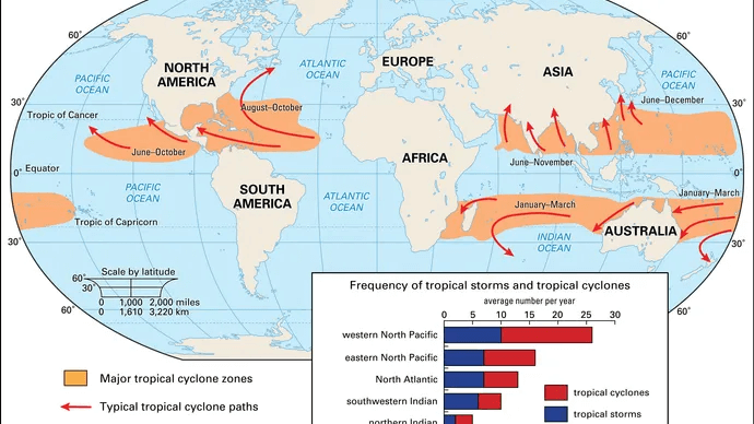
Favourite Breeding Grounds for Tropical Cyclones
• South-east Caribbean region where they are called hurricanes.
• Philippines islands, eastern China and Japan where they are called typhoons.
• Bay of Bengal and Arabian Sea where they are called cyclones.
• Around south-east African coast and Madagascar-Mauritius islands.
• North-west Australia.
Regional names for Tropical Cyclones
What is the difference between Cyclones, Hurricanes, Typhoons and Willy-Willies?
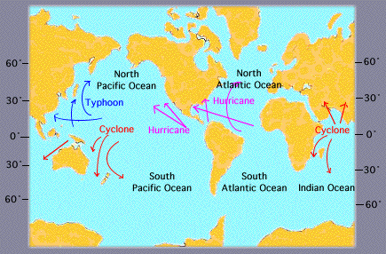
All these are regional names of tropical cyclones.
Region – Name
Indian Ocean – Cyclones
Atlantic – Hurricanes
Western Pacific & S. China Sea – Typhoons
Western Australia – Willy-willies
Characteristics of a Tropical Cyclones
Size and Shape
• Tropical cyclones have symmetrical elliptical shapes (2:3 ratio of length and breadth) with steep pressure gradients. They have a compact size—80 km near center, which may develop up to 300 km to 1500 km.
Wind Velocity and Strength
• Wind velocity, in a tropical cyclone, is more in poleward margins than at center and is more over oceans than over landmasses, which are scattered with physical barriers. The wind velocity may range from nil to 1200 km per hour.
Path of Tropical Cyclones
• These cyclones start with a westward movement, but turn northwards around 20° latitude. They turn further north-eastwards around 25° latitude, and then eastwards around 30° latitude. They then lose energy and subside.
• Tropical cyclones follow a parabolic path, their axis being parallel to the isobars.
• Coriolis force or earth’s rotation, easterly and westerly winds influence the path of a tropical cyclone.
• Tropical cyclones die at 30° latitude because of cool ocean waters and increasing wind shear due to westerlies.