
Satellites offer our eyes a unique perspective on Earth, but their vision isn’t a boundless panorama. Instead, it’s composed of focused observations shaped by two crucial concepts: swath and nadir. Mastering these terms unlocks the potential of satellite imagery, allowing us to delve deeper into our planet’s secrets.
Swath: Scanning the Landscape
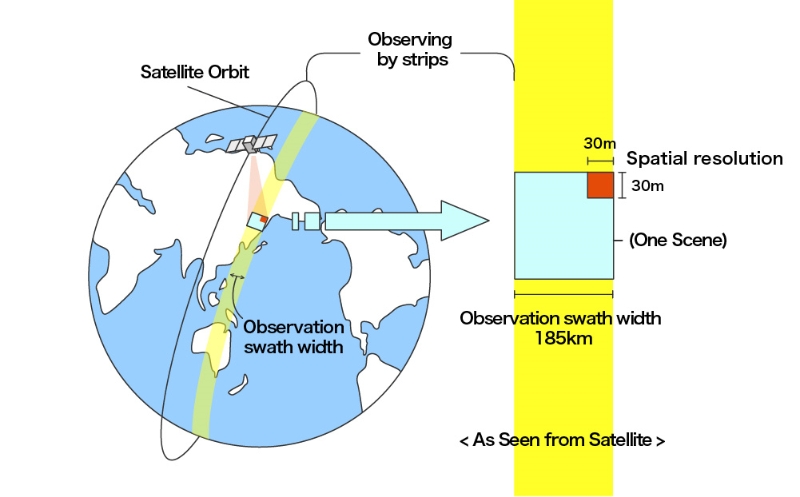
Imagine the satellite’s sensor as a high-tech paintbrush, sweeping across the Earth’s surface with each pass. The swath represents the width of this stroke, the area captured in a single pass. This width varies dramatically depending on the satellite’s purpose and technology:
- Environmental monitoring often relies on satellites boasting swaths of 200 kilometres or more. These behemoths can image entire continents in a single sweep, ideal for tracking global phenomena like deforestation, cloud cover, and temperature changes.
- Zooming in, high-resolution satellites narrow their swaths to a mere 10 kilometres or less. This focused gaze reveals incredible detail, from individual buildings and intricate urban patterns to the health of individual trees. Such narrow swaths are invaluable for resource exploration, infrastructure monitoring, and precision agriculture.
Beyond sensor power, the imaging technique plays a crucial role. Optical sensors, sensitive to reflected light, typically offer wider swaths due to the diffuse nature of light. Conversely, radar satellites emit focused beams, resulting in narrower swaths but often revealing details obscured by clouds or vegetation.
Understanding swath width isn’t just academic knowledge; it’s critical for efficient data acquisition. Consider capturing a high-resolution image of the Amazon rainforest. With a narrow swath satellite, multiple passes and meticulous stitching are required to assemble the complete picture. Knowing the swath width empowers us to choose the right tool for the job, ensuring efficient data collection and avoiding gaps in coverage.
Nadir: The Point of Precision
Now, picture yourself standing directly under the satellite, bathed in its analytical gaze. The point on the ground directly below, the bullseye of its attention, is the nadir. Here, data shines with its highest quality and detail, distortions are minimal, and features are most recognizable.
The nadir serves as the image’s reference point, the cornerstone against which other areas are calibrated and aligned. Measurements made at the nadir are often the most accurate, making it vital for tasks like mapping, surveying, and monitoring subtle changes.
However, the satellite’s view isn’t confined to the perfect nadir. As it sweeps across its swath, the viewing angle deviates, introducing the “off-nadir” perspective. This tilt from the ideal vertical position isn’t without consequences. Details might blur, become skewed, or even disappear altogether as the angle increases.
But off-nadir viewing isn’t inherently inferior. Just like tilting your head reveals different aspects of a painting, it can offer unique insights into satellite imagery. Studying a volcanic eruption from a slightly off-nadir angle might reveal the full plume’s extent, while a nadir view only shows its base. This perspective is crucial for disaster management and volcanic activity monitoring.
Swath and Nadir: A Partnership in Information
Swath and nadir are not isolated concepts; they are partners in a dance of information. Understanding their interplay is key to interpreting satellite images effectively. By appreciating the strengths and limitations of each, we can make informed decisions about which satellite and imaging technique is best suited for our specific needs.
For instance, mapping deforestation across vast areas like the Amazon might prioritize a wide swath for coverage, even at the expense of some detail. Conversely, studying the health of individual coral reefs would necessitate a high-resolution, narrow swath with a clear nadir point for accurate measurements.